
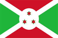
Burundi
|
|
Basic Info
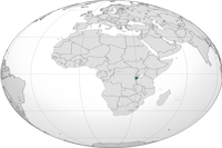
Burundi, officially the Republic of Burundi, is a landlocked country in the Great Lakes region of Eastern Africa, bordered by Rwanda to the north, Tanzania to the east and south and the Democratic Republic of the Congo to the west. Its capital is Bujumbura. Although the country is landlocked, much of the southwestern border is adjacent to Lake Tanganyika.
Geography
One of the smallest countries in Africa, Burundi is landlocked and has an equatorial climate. Burundi is a part of the Albertine Rift, the western extension of the East African Rift. The country lies on a rolling plateau in the center of Africa. The average elevation of the central plateau is 5,600 feet (1,707 m), with lower elevations at the borders. The highest peak, Mount Heha at 8,810 feet (2,685 m), lies to the southeast of the capital, Bujumbura. The source of the Nile River is in Burundi province, and is linked from Lake Victoria to its headwaters via the Ruvyironza River Lake Victoria is also an important water source, which serves as a fork to the Kagera River. Another major lake is Lake Tanganyika, located in much of Burundi's southwestern corner
Climate
Burundi in general has a tropical highland climate, with a considerable daily temperature range in many areas. Temperature also varies considerably from one region to another, chiefly as a result of differences in altitude. The central plateau enjoys pleasantly cool weather, with an average temperature of 20 °C (68 °F). The area around Lake Tanganyika is warmer, averaging 23 °C (73.4 °F); the highest mountain areas are cooler, averaging 16 °C (60.8 °F).
Bujumbura's average annual temperature is 23 °C (73.4 °F). Rain is irregular, falling most heavily in the northwest. Dry seasons vary in length, and there are sometimes long periods of drought. However, four seasons can be distinguished: the long dry season (June–August), the short wet season (September–November), the short dry season (December–January), and the long wet season (February–May). Most of Burundi receives between 1,300 and 1,600 mm (51.2 and 63.0 in) of rainfall a year. The Ruzizi Plain and the northeast receive between 750 and 1,000 mm (29.5 and 39.4 in).
Religion
Sources estimate the Christian population to be 75%, with Roman Catholics representing the largest group at 60%. Protestant and Anglican practitioners constitute the remaining 15%. An estimated 20% of the population adheres to traditional indigenous religious beliefs. The muslim population is estimated to be at 5%, the majority of whom live in urban areas. Sunnis make up the majority of the muslim population, the remainder being Shi'a.
Administrative divisions
Burundi is divided into 17 provinces, 117 communes, and 2,638 collines (hills). Provincial governments are structured upon these boundaries. In 2000, the province encompassing Bujumbura was separated into two provinces, Bujumbura Rural and Bunjumbura Mairie.
The provinces are:
 |
Site Search
News
Random Articals
Weather
Join Our Newsletter
Send This Page to Friend
To Email this page to a friend
1. Use Your Default Email Client
2. Use Our Recommend Page
Online Contact
nouahsark
1438084734
+ 86 158 00 323 707
+ 86 158 00 323 707
nouahsark@hotmail.com
If you like this article please feel free to share it to your favorite site listed below: