
Equatorial Guinea
|
|

Basic Info
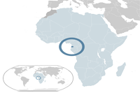
Equatorial Guinea, officially the Republic of Equatorial Guinea, (Spanish: República de Guinea Ecuatorial, is a country located in Middle Africa. With an area of 28,000 square kilometres (11,000 sq mi) Equatorial Guinea is one of the smallest countries in continental Africa. It has two parts, an insular and a mainland region. The insular region, consists of the islands of Bioko (formerly Fernando Pó), in the Gulf of Guinea, and Annobón, a small volcanic island south of the equator. Bioko island is the northernmost part of Equatorial Guinea and is where the country's capital, Malabo, is situated.
The island nation of São Tomé and Príncipe is located between Bioko and Annobón. The mainland region, Río Muni, is bordered by Cameroon on the north, Gabon on the south and east. It also includes several small offshore islands (such as Corisco, Elobey Grande and Elobey Chico).
Geography
Equatorial Guinea is located in west central Africa. The country consists of a mainland territory, Río Muni, which is bordered by Cameroon to the north and Gabon to the east and south, and five small islands, Bioko, Corisco, Annobón, Elobey Chico (Small Elobey), and Elobey Grande (Great Elobey). Bioko, the site of the capital, Malabo, lies about 40 kilometers (25 mi) off the coast of Cameroon. Annobón Island is about 350 kilometers (220 mi) west-south-west of Cape Lopez in Gabon. Corisco and the two Elobey islands are in Corisco Bay, on the border of Río Muni and Gabon.
Climate
Equatorial Guinea has a tropical climate with distinct wet and dry seasons. From June to August, Río Muni is dry and Bioko wet; from December to February, the reverse occurs. In between there is gradual transition. Rain or mist occurs daily on Annobón, where a cloudless day has never been registered. The temperature at Malabo, Bioko, ranges from 16 °C (61 °F) to 33 °C (91 °F), though on the southern Moka Plateau normal high temperatures are only 21 °C (70 °F). In Río Muni, the average temperature is about 27 °C (81 °F). Annual rainfall varies from 1,930 mm (76 in) at Malabo to 10,920 mm (430 in) at Ureka, Bioko, but Río Muni is somewhat drier
Religion
The principal religion in Equatorial Guinea is Christianity which is the faith of 93% of the population. These are predominately Roman Catholic (87%) while a minority are Protestants (5%). Another 5% of the population follow indigenous beliefs and the final 2% comprises muslims, Bahá'í Faith, and other beliefs
Administrative divisions
|  |
Site Search
News
Random Articals
Weather
Join Our Newsletter
Send This Page to Friend
To Email this page to a friend
1. Use Your Default Email Client
2. Use Our Recommend Page
Online Contact
nouahsark
1438084734
+ 86 158 00 323 707
+ 86 158 00 323 707
nouahsark@hotmail.com
If you like this article please feel free to share it to your favorite site listed below: