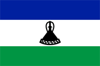
Lesotho
|
|

Basic Info
Lesotho, officially the Kingdom of Lesotho, is a landlocked country and enclave, completely surrounded by its only neighbouring country, the Republic of South Africa. It is just over 30,000 km2 (11,583 sq mi) in size and has a population of approximately 2,067,000. Its capital and largest city is Maseru. Lesotho is a member of the Commonwealth of Nations. The name Lesotho translates roughly into the land of the people who speak Sesotho. About 40% of the population live below the international poverty line of US $1.25 a day

Geography
Lesotho covers 30,355 km2 (11,720 sq mi). It is the only independent state in the world that lies entirely above 1,000 metres (3,281 ft) in elevation. Its lowest point of 1,400 metres (4,593 ft) is thus the highest in the world. Over 80% of the country lies above 1,800 metres (5,906 ft). Lesotho is also the southernmost landlocked country in the world and is entirely surrounded by the country of South Africa. It lies between latitudes 28° and 31°S, and longitudes 27° and 30°E.
Climate
Because of its altitude, Lesotho remains cooler throughout the year than other regions at the same latitude. Most of the rain falls as summer thunderstorms. Maseru and surrounding lowlands often reach 30 °C (86 °F) in summer. Winters can be cold with the lowlands getting down to −7 °C (19 °F) and the highlands to −18 °C (−0 °F) at times. Snow is common in the highlands between May and September; the higher peaks can experience snowfalls year-round.
Religion
The population of Lesotho is estimated to be around 90% Christian. Protestants represent 45% of the population (Evangelicals 26%, and Anglican and other Protestant groups an additional 19%), and Roman Catholics represent 45 percent of the population. Members of other religions (muslims, Hindus, Buddhists, Baha'i, and members of traditional indigenous religions) comprise the remaining 10% of the population.
Administrative divisions
For administrative purposes, Lesotho is divided into ten districts, each headed by a district administrator. Each district has a capital known as a camptown.
 |
Site Search
News
Random Articals
Weather
Join Our Newsletter
Send This Page to Friend
To Email this page to a friend
1. Use Your Default Email Client
2. Use Our Recommend Page
Online Contact
nouahsark
1438084734
+ 86 158 00 323 707
+ 86 158 00 323 707
nouahsark@hotmail.com

If you like this article please feel free to share it to your favorite site listed below: