
Cape Verde
|
|

Basic Info
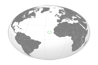
Cape Verde, officially the Republic of Cape Verde, is an island country, spanning an archipelago of 10 islands located in the central Atlantic Ocean, 570 kilometres (350 miles) off the coast of Western Africa. The islands, covering a combined area of slightly over 4,000 square kilometres (1,500 sq mi), are of volcanic origin and while three of them (Sal, Boa Vista and Maio) are fairly flat, sandy and dry, the remaining ones are generally rockier and have more vegetation.
Geography
The Cape Verde archipelago is located in the Atlantic Ocean, approximately 570 kilometres (350 mi) off the coast of West Africa, near Senegal, The Gambia and Mauritania, and is part of the Macaronesia ecoregion. It lies between latitudes 14° and 18°N, and longitudes 22° and 26°W.
Climate
Cape Verde's climate is milder than that of the African mainland because the surrounding sea moderates temperatures on the islands. Average daily high temperatures range from 23 °C (73 °F) in January to 29 °C (84.2 °F) in September. Cape Verde is part of the Sahelian arid belt, with nothing like the rainfall levels of nearby West Africa. It does rain irregularly between August and October, with frequent brief-but-heavy downpours. A desert is usually defined as terrain which receives less than 250 mm (9.8 in) of annual rainfall. Cape Verde's total (265 mm/10.4 in) is slightly above this criterion, which makes the area climate semi-desert.
Religion
Roman Catholic (infused with indigenous beliefs); Protestant (mostly Church of the Nazarene), Buddhist 0.2%
Administrative divisions
Cape Verde is divided into 22 municipalities (concelhos) and subdivided into 32 parishes (freguesias), based on the religious parishes that existed during the colonial period:
 |
|
||||||||||||||||||||||
|
|
|
|||||||||||||||||||||||||||||||
Site Search
News
Random Articals
Weather
Join Our Newsletter
Send This Page to Friend
To Email this page to a friend
1. Use Your Default Email Client
2. Use Our Recommend Page
Online Contact
nouahsark
1438084734
+ 86 158 00 323 707
+ 86 158 00 323 707
nouahsark@hotmail.com
If you like this article please feel free to share it to your favorite site listed below: