
Grenada
|
|
Basic Info
Grenada, is an island country and Commonwealth realm consisting of the island of Grenada and six smaller islands at the southern end of the Grenadines in the southeastern Caribbean Sea. Grenada is located northwest of Trinidad and Tobago, northeast of Venezuela, and southwest of Saint Vincent and the Grenadines.
Grenada is also known as the "Island of Spice" because of the production of nutmeg and mace crops of which Grenada is one of the world's largest exporters. Its size is 344 square kilometres (133 sq mi), with an estimated population of 110,000. Its capital is St. George's. The national bird of Grenada is the critically endangered Grenada Dove.

Geography
The island of Grenada is the largest island in the Grenadines; smaller islands are Carriacou, Petit Martinique, Ronde Island, Caille Island, Diamond Island, Large Island, Saline Island, and Frigate Island. Most of the population lives on Grenada, and major towns there include the capital, St. George's, Grenville and Gouyave. The largest settlement on the other islands is Hillsborough on Carriacou.
Climate
The islands are of volcanic origin with extremely rich soil. Grenada's interior is very mountainous with Mount St. Catherine being the highest at 840 m. Several small rivers with beautiful waterfalls flow into the sea from these mountains. The climate is tropical: hot and humid in the rainy season and cooled by the trade winds in the dry season. Grenada, being on the southern edge of the hurricane belt, has suffered only three hurricanes in fifty years.
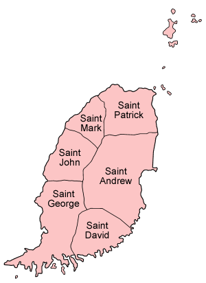
Administrative divisions
The Caribbean island country of Grenada is divided into regions known as parishes.
A parish defines a territorial unit or region that, historically, was usually an area under the pastoral care served by a local church as an ecclesiastical administrative unit (see Parish) and later used by map-makers to set boundaries to an area of land. Traditionally a settlement or village would centre around a church and later grow to become a town and then even a city. Therefore a parish has now come to mean an administrative division and is used so by several countries as the smallest unit (or lowest tier) of local government.
Site Search
News
Random Articals
Weather
Join Our Newsletter
Send This Page to Friend
To Email this page to a friend
1. Use Your Default Email Client
2. Use Our Recommend Page
Online Contact
nouahsark
1438084734
+ 86 158 00 323 707
+ 86 158 00 323 707
nouahsark@hotmail.com
If you like this article please feel free to share it to your favorite site listed below: