
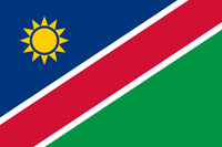
Namibia
|
|
Basic Info
Namibia, officially the Republic of Namibia (Afrikaans: Republiek van Namibië, German: Republik Namibia), is a country in southern Africa whose western border is the Atlantic Ocean. It shares land borders with Angola and Zambia to the north, Botswana to the east and South Africa to the south and east. Although it does not border with Zimbabwe, less than 200 meters of riverbed (essentially the Zambia/Botswana border) separates them at their closest points. It gained independence from South Africa on 21 March 1990, following the Namibian War of Independence. Its capital and largest city is Windhoek. Namibia is a member state of the United Nations (UN), the Southern African Development Community (SADC), the African Union (AU), and the Commonwealth of Nations.

Geography
At 825,418 km2 (318,696 sq mi), Namibia is the world's thirty-fourth largest country (after Venezuela). It lies mostly between latitudes 17° and 29°S (a small area is north of 17°), and longitudes 11° and 26°E.
Climate
Weather and climate in the coastal area are dominated by the cold, north-flowing Benguela current of the Atlantic Ocean which accounts for very low precipitation (50 mm per year or less), frequent dense fog, and overall lower temperatures than in the rest of the country. In Winter, occasionally a condition known as Bergwind or Oosweer (Afrikaans: East weather) occurs, a hot dry wind blowing from the inland to the coast. As the area behind the coast is a desert, these winds can develop into sand storms with sand deposits in the Atlantic Ocean visible on satellite images
Religion
The Christian community makes up 80%–90% of the population of Namibia, with at least 50% of these Lutheran. 10%–20% of the population hold indigenous beliefs.
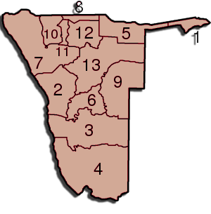
Administrative divisions
Namibia is divided into 13 regions and subdivided into 107 constituencies. The administrative division of Namibia is tabled by Delimitation Commissions and accepted or declined by the National Assembly. Since state foundation three Delimitation Commissions have been formed, the last one in 2002 under the chairmanship of Peter Shivute. Regional councillors are directly elected through secret ballots (regional elections) by the inhabitants of their constituencies.
|  |
Site Search
News
Random Articals
Weather
Join Our Newsletter
Send This Page to Friend
To Email this page to a friend
1. Use Your Default Email Client
2. Use Our Recommend Page
Online Contact
nouahsark
1438084734
+ 86 158 00 323 707
+ 86 158 00 323 707
nouahsark@hotmail.com
If you like this article please feel free to share it to your favorite site listed below: